Trail Mountain bike La Chapelle - 20191004 Yeyette à Givonne jour 1 - Photo

20191004 Yeyette à Givonne jour 1

Plus vî, plus sot

© OpenStreetMap contributors
Length
Length
26 km
Max alt
Max alt
440 m
Uphill gradient
Uphill gradient
521 m
Km-Effort
Km-Effort  
33 km
Min alt
Min alt
275 m
Downhill gradient
Downhill gradient
521 m
Boucle
Boucle
Yes
Creation date :
2019-10-04 12:09:36.0
Updated on :
2019-10-07 09:36:37.816

(0 Reviews)

Mountain bike
Mountain bike
3h01
Difficulty : Difficult

Scan this QR Code to open this trail in the SityTrail application

FREE GPS app for hiking

Logo SityTrail SityTrail

IGN / Geographical institutes

Download SityTrail from the App Store Download SityTrail from Google Play

Logo SityTrail SityTrail World

The world is yours!

Download SityTrail from the App Store Download SityTrail from Google Play Download SityTrail on Huawei AppGallery

About

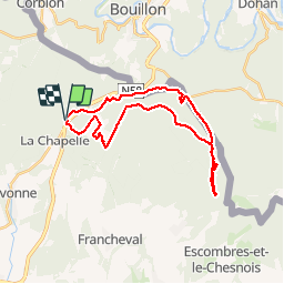
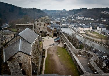
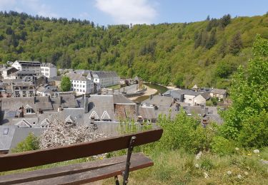
Trail Mountain bike of 26 km to be discovered at Grand Est, Ardennes, La Chapelle. This trail is proposed by Yeyette VTT team.

Description

Bououououe le long de la frontière belge

Elevation profile

Photos

Positioning

Country:
France
Region :
Grand Est
Department/Province :
Ardennes
Municipality :
La Chapelle
Location:
Unknown
Start:(UTM)
645720 ; 5512813 (31U) N.

Trails nearby

Trail Walking Bouillon - RB-LUX-13 - Les belvédères bouillonnais - Photo
Walking
PRO

Walking

Medium
(7)
Bouillon, Wallonia, Luxembourg, Belgium
20 km | 30 km-effort
5h 55min
Yes
Trail Walking Bouillon - RB-LUX-13 - Raccourci - Les belvédères bouillonnais - Photo
Walking
PRO

Walking

Medium
(4)
Bouillon, Wallonia, Luxembourg, Belgium
16.7 km | 25 km-effort
4h 54min
Yes
Trail Walking Bouillon - Promenade vers la Passerelle de l’épine  - Photo
Walking
GUIDE+

Walking

Medium
(6)
Bouillon, Wallonia, Luxembourg, Belgium
7.3 km | 11.2 km-effort
2h 33min
Yes
Trail Walking Illy - Chemin des contrebandiers - Illy - Photo
Walking
tracegps

Walking

Easy
(2)
Illy, Grand Est, Ardennes, France
7.9 km | 9.9 km-effort
1h 55min
Yes
Trail Walking Bouillon - Noordelijke bossen Bouillon 15 km - Photo
Walking
mavbelgium

Walking

Very difficult
(1)
Bouillon, Wallonia, Luxembourg, Belgium
16.2 km | 24 km-effort
3h 43min
Yes
Trail Walking Bouillon - De Bouillon vers Corbion par le Tombeau du Geant - Photo
Walking
GUIDE
Desrumaux

Walking

Difficult
(5)
Bouillon, Wallonia, Luxembourg, Belgium
20 km | 30 km-effort
5h 0min
Yes
Trail On foot Bouillon - Promenade de la Ramonette et arboretum 8 - Photo
On foot
PRO

On foot

Easy
(1)
Bouillon, Wallonia, Luxembourg, Belgium
3.9 km | 6.1 km-effort
1h 23min
Yes
Trail On foot Bouillon - Promenade gros chêne français et chêne des Mouches 21 - Photo
On foot
GUIDE+

On foot

Easy
Bouillon, Wallonia, Luxembourg, Belgium
9.7 km | 13.3 km-effort
3h 1min
Yes
Trail On foot Bouillon - Promenade de la Sente aux Geais - Photo
On foot
GUIDE+

On foot

Easy
Bouillon, Wallonia, Luxembourg, Belgium
3.3 km | 4.2 km-effort
57min
Yes


Close
My subscriptions